3D Model of Detroit, MI
Accurate & Usable city centre models to fit your needs
3D city model of Detroit, Michigan is the AccuCities’ first city mapping project outside Europe is in the USA. It is the latest addition to our 3D cities library. All urban landscape features were 3D mapped from the latest aerial survey data from 2020 using manual stereophotogrammetry. Models are delivered as digital downloads in a variety of the most common file formats used by architects and urban designers.

3D Model of Detroit Features
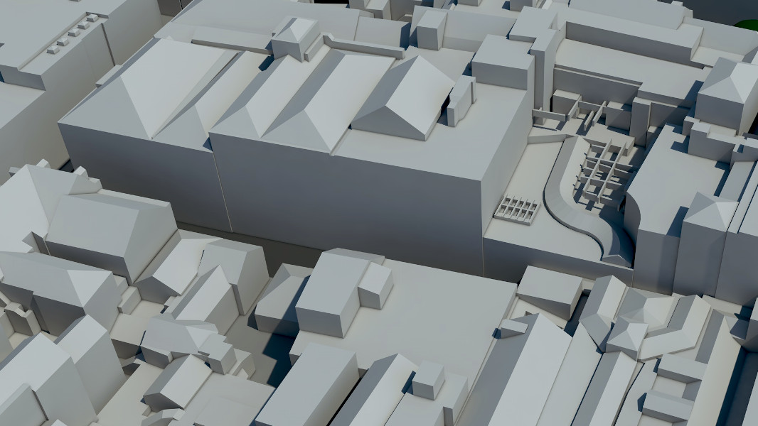
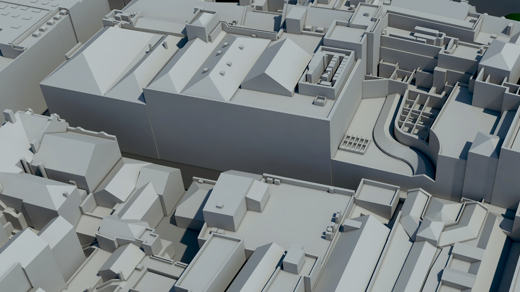
The 3D dataset has been manually captured from the 2018 High-Res imagery by our team of skilled technicians using stereophotogrammetry. High-detail model is accurate to 15cm (6 inches) in all axes with all roof features such as chimneys, parapet walls and dorm windows captured with the correct shape and tilt. The Detroit City Centre 3D Model has been originally captured for an urban AI/machine learning project.
Real estate developers, architects and city planners are the usual customers for our 3D city models. In combination with Plan.city, this 3D city model gives our US customers some of the most advanced urban design tools straight out of the box. Read the latest Case Studies.

9km2 3D Detroit Model Map
Ready-made digital city twin model
AccuCities Detroit model on a wide area map. Yellow area shows extents of the free 3D Detroit sample. Customers can licence the entire dataset, buy individual tiles or commission a custom 3D model.

City model in WGS 84 coordinate system
Affordable city models with 1 day delivery
3D city model of Detroit is structured in tiles that align with WGS 84 / UTM zone 17N (EPSG:32617) coordinate system. Detroit models are available in a High Level of Detail with < 6-inch accuracy.

Detailed & Accurate 3D city model
Manually captured from Aerial Survey
The 3D dataset has been manually captured from the 2018 aerial survey. Accurate to 15cm (6 inches) in all axes. All roof features such as chimneys, parapet walls and dorm windows are captured with the correct shape and tilt.

Accurate 3D terrain in land-use layers
Traffic Simulations & CGI ready
The terrain is not flat but is captured in 3D. Break lines curbs of roads, along green spaces and footpaths as well as any significant change in terrain profile and separated into layers.

3D city model for the industry
From Architecture to Zero carbon research applications
We supply the existing digital model tiles on the same day for $1,000 per 0.25 km2 tile. Additional areas of Detroit can be produced in as little as 7 working days.

Free 3D Detroit samples
View Free CAD and SketchUp samples
This free 3D Detroit model represents an individual 500 x 500 meter tile. View & Download AutoCad .DWG, .FBX and SketchUp .SKP files.

Free Textured 3D Detroit sample
Accurate & Textured FBX model sample
This textured 3D Detroit model represents an individual 500 x 500 meter tile. The 3D model is UV mapped & Textured, available in FBX format.
Level 2 models (Medium Detail)
Mostly used in architectural competitions, context for BIM models, backgrounds for architectural visualisation, CGI, info animations, initial planning proposals, wider area 3D printing, home 3D printing, games and mobile application requiring low-poly models.
Level 3 models (High Detail)
Mostly used in planning, environmental and building consultancy services, development proposals, wind studies, context for architectural and BIM models, real estate, marketing, high-end architectural visualisation, CGI, animations & High-End 3D printing.
3D models are distributed under company-wide, multiple-use licence which covers the use of the 3D model for 5 years. We grant to the User a worldwide, non-exclusive licence to use the 3D Model to unlimited number of Derived products (renders, animations), Incorporated products (Interactive Application, import into custom software), conduct In-house work and use 3D Model data for Physicalization such as 3D printing.
Customers cannot distribute, alter to distribute or re-engineer the 3D model in any way. Read full EULA here.
AccuCities 3D London app is now Plan.City! Please get in touch and we will be happy to set up a meeting to demo the app.
Both Level 2 and Level 3 3D Models are manually captured from latest aerial imagery available for the area of interest.
 Level 2 3D Models are accurate to 50 cm in all axis. The 3D Model is very light and low poly. Buildings are captured with correct roof shapes of main structures with only chimneys, parapet walls and dormer windows omitted. Terrain is accurate to 20 cm and separated into land use categories. Trees locations (captured with correct height and canopy width) are also included.
 Level 3 3D Models are accurate to 15 cm in all axis. Buildings are captured with correct roof shapes and all features such as chimneys, parapet walls or dormer windows. Terrain is separated into land use categories. Trees locations (captured with correct height and canopy width) are also included.
Any model can be delivered as AutoCad solid .DWG, SketchUp .SKP or .FBX files.
Our High Detail 3D Model of London subscribers also receive Unreal Engine 4 app and all associated UE4 files.
Of course – feel free to Download AccuCities sample tile TQ3280SE. This large 500 x 500 meters sample can be used to evaluate our 3D models. The sample can be downloaded as AutoCad solid .DWG, SketchUp .SKP, FBX and .UE4 Project files as well as Interactive 3D Model. Different Levels of Detail 3D models are available in every format.
You don’t need to have an account with us to order 3D models.
We offer up to 80% discounts for students / non-profit projects. Send us your required area via our Quoting Tool and use “Student” instead of company name. Best of luck in your studies!
Either Level 2 or Level 3 models can be ordered from as little as 0.1 km2 (which is about 330 x 330 meters in real world).
Custom 3D models can be ordered in any shape – simply draw a map mark-up , send it over to us and we will come back to you with a quote.
We prefer map mark-ups for quotes to be sent via our Quoting Tool. If you are having any difficulties or have a map in any other format, simply email it to info@accucities.com with your name, company, required Level of Detail and your contact details and we will come back to you.
Business customers will be invoiced with 14 days payment term in or shortly after 3D model delivery. Non-business customers might be asked to pay via Card, PayPal or UK money transfer before we accept an order.
We will usually come back to you within 2 hours with costs and delivery times for your project. Once these are confirmed by you we will order imagery, set-up a Photogrammetry project, manually capture your 3D model, post process the data and deliver the 3D model to you in required format via a download link.
High-detail 3D Detroit Tile
- Unlimited Projects
- 5 Years Licence
- 0.25 km2 Area
- 15 cm Accuracy
9 km2 Detroit Model Subscription
- Unlimited Projects
- 1 Year Licence
- 9 km2 Area
- 15 cm Accuracy
Existing Subscription Add-On from
- Unlimited Projects
- 1 Year Licence
- 9+ km2 Area
- 15 cm Accuracy
Top Architects use AccuCities 3D City Models
