Latest News from AccuCities
Articles, Projects & Activities
This is the place where we announce the latest company news, case studies and showcase interesting 3D models capture. You can also read articles on 3D cities capture & Photogrammetry, Research and Machine Learning, 3D City Models, Unreal Engine 4 and Plan.City work. We are also publishing all Awards & Trophies we have received over the time.
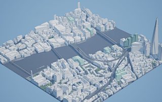
Free 3D Model of London 2025 Samples
Our brand new 3D Model of London 2025 is almost out and free samples of the model are out now! To create our 3D London model, every point and every line is manually captured using stereo photogrammetry. But having a 5 or 10 year old city model is of a very limited use to planners and architects. Tha ...
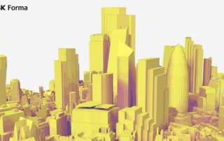
Autodesk Forma: London Context by AccuCities
Autodesk Forma® users can now enhance their design process with high quality contextual data from AccuCities, available directly in the Accucities Forma Contextual Data Market Card – giving architects and designers a “flying start” on their projects. What is Autodesk Forma Site Design Forma Sit ...
YouTube Course: Master Plan.City London
This YouTube Course will demonstrate how to master Plan.City London, a set of site evaluation & presentation tools for Architects, Urban Planners and Developers. The application includes large, accurate and up-to date 3D model of London and even the Future Skyline Layer to better understand the ...

Make Architects Building Centre Exhibition
Make’s first retrospective public exhibition ‘CO-CREATE’ is now open at the Building Centre! To celebrate, MAKE Architects hosted a drinks reception launch for our Makers, clients and collaborators. Come see over 70 architectural models, maquettes, sketches, films, and materials marking two decades ...
3D Site models with Cutbacks and Windows
Cutbacks and windows locations on a 3D site model allows customers to directly conduct many studies such as daylight, sunlight, overshadowing or glare analysis. AccuCities now offers cutback and facade openings 3D models upgrade, in most cases not requiring a site visit or additional survey. Doors ...
3D Models of Buildings for Window Cleaners
The world of high-tech window cleaning requires clear communication between client and the service provider. AccuCities provides tailored 3D models for many specialist applications and 3D models for window cleaning clients are one of them. Facility Apps allows Window Cleaners to have a 3D visibility ...
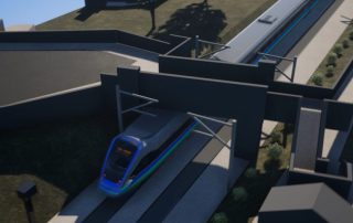
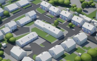
Accurate Base Models for Civil Engine
Accurate, detailed and up-to-date base models are a prerequisite for Civil Engine, an innovative specialized 3D visualization software designed for transportation and other civil engineering projects. It enables professionals to create high-quality visualizations quickly and efficiently without the ...
Plan.City London Summer 2025 Update
Plan.City London has received much more than a quick update this summer. With the release of Unreal Engine 5 a couple of years ago, we've been working on taking advantage of the new technologies available through the newest version of the engine, as well as continuing to revamp and expand the data l ...
Free Samples of Infrastructure 3D Models
AccuCities provides 3D models of infrastructure for all kinds of studies and assessments. Our 3D maps are used for anything to do with infrastructure, from simple Visibility Analysis all the way to Glare and Wind Analysis. To give customers the opportunity to evaluate whether AccuCities 3D site mod ...

Realistic 3D London model for Videogames
For our photo-realistic 3D city model of London for videogames, we manually capture all details on facades on top of our accurate Level 3 city model. We UV map the models, apply materials and textures. All the way to the last architectural detail, with high accuracy and precision. Where necessary, w ...

3D models in Consultancy by MBS Daylight
AccuCities 3D site models are used in the workflow of many planning consultants. As providers of “Daylight” software, MBS Daylight offers unique collaboration with Architects, Developers and Consultants. They can be involved throughout the daylight design process, offering their client to tap into ...

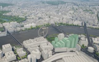
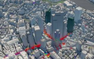
London Future Skyline Staff Picks
The Future London Skyline 3D models are created, managed & updated in-house by AccuCities. Future Skyline layer ensures that our 3D London model is as up-to-date and useful to our customers as possible. 3D models of skyscrapers and landmarks with planning permission already granted are continuo ...

Trafalgar Square Junior NBA Renders for LME
London Marathon Events and the NBA chose Trafalgar Square as a venue for the inaugural Finals of Jr. NBA 3v3. To communicate its vision, LME turned to AccuCities to create the infographics renders of the set-up in the shadow of Nelson’s Column. AccuCities have collaborated closely with organisers t ...

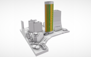
Solar Overshadowing Assessments by DPR
DPR typically carries a Solar photovoltaic (PV) overshadowing assessment alongside daylight and sunlight studies at the pre-application stage. They use advanced simulation techniques on an accurate and detailed 3D site models to simulate the development’s impact on sunlight reaching neighboring sol ...

Latest AccuCities Customers Reviews
AccuCities is a customer-centred operation. It is therefore no surprise that we have the highest number of Customer Reviews on Google from all 3D mapping services providers. Previous AccuCities Reviews are here. For over 7 years, we are supplying some of the most demanding industries in some of the ...

Urban Planning in Unreal Engine 5 | Plan.City
Game Engines such as Epic Games’ Unreal Engine 5 are often used by architects to create visualisations and interactive presentations as well as for urban planning purposes. UE5-powered Plan.City is used by architects, planners and consultants. It allows them to quickly create and explore design ite ...

Daylight & Sunlight Layout Planning by AH
Custom AccuCities 3D site model of Slough Trading Estate has been used by Anstey Horne to conduct Vertical Sky Component (VSC) testing to the façades of the neighboring residential properties in the immediate vicinity of the site. The results of this study indicated what extent the daylight (VSC) o ...

Accurate, Detailed and Up-to-Date 3D London
AccuCities, a London-based specialist in 3D city modeling, has been instrumental in delivering accurate, highly detailed and current models of London to the AEC industry. Up-to-date 3D city models are instrumental in conducting environmental analyses, such as pedestrian wind modelling, daylight, sun ...

Plan.City Integration with MBS Software
Plan.City + MBS is an industry-funded presentation toolset application, jointly developed by AccuCities and MBS Survey Software. It allows users to import and display results data exported from MBS software in a visually attractive 3D environment with easy navigation. The application is now release ...

Re:Imagine London – ZHA collab with Epic Games
Re:Imagine London is a creative experience played in Fortnite, one of the world's most popular video games. Using Epic Games' Unreal Editor for Fortnite (UEFN), Re:Imagine London has been jointly developed by Zaha Hadid Architects and Epic Games to research the use of UEFN for practical application ...