Context 3D Models for Planning
Now with Free Project licence upgrade
The Planning Portal and AccuCities® have teamed up to allow customers to make their custom 3D site models part of their Planning Applications. Leading the way in digitising the planning process, the project aims to reduce the number of rejected planning application by making the use and sharing of 3D context models simpler and more affordable. Everybody working on a project can use the same 3D context model data.
Top Planning Consultants use AccuCities 3D city models

Free Upgrade to Project Licence
Make context 3D model part of your Planning Application
Planning Portal has teamed up with AccuCities to give you a FREE upgrade of the 3D model licence to a Project Licence. This upgrade is normally charged at 150% of a listed price for a 3D model, saving you at least £300!
The long 5 year Project licence allows you to share your site model freely – any stakeholder working on a project, from developers and architects to planning consultants and even local authority can use this 3D model. Avoid delays and errors and make your context 3D model part of your Planning Application.
Buy Custom 3D Models for Planning
Use our Quoting Tool for Instant Cost & Delivery Times estimates
Using our Quoting Tool is usually the quickest way to send us your requirements for a quote; the system now also displays Project Cost & Delivery time estimates* for your context 3D model. Simply find your site on a map and choose from one of the set-area boxes or draw an exact site boundary shape. If your site is already covered by our existing 3D city models library, the Quoting Tool will also display a clickable box grid of all available 500 x 500 meters tiles**. Enter your details and send us your quote request. We aim to come back to you within a few hours with a binding quote and payment options.
If you prefer, you can email us your site mark-up, map mark-up, 2D map or any other info about your site. Feel free to call our Call our Customer Support or Contact Us individually.
* The Quoting system displays conservative estimates of the Project Cost & Delivery timescales. We offer further discounts for sites over 1 square kilometer and for customers requiring our services on on number of 3D mapping projects. Please contact us to discuss.
** Tiled city models are priced per Tile with the 1-day delivery.
Custom 3D Models Examples & Samples
Supplying Architects and Planners Since 2017
Examples of previously delivered custom 3D Models used primary for Planning. See project cost & delivery times below. You can view these examples using online viewer or even download them in CAD, SketchUp or FBX formats. Samples are available in both local and UK national grid coordinates.


Top Architects use AccuCities 3D City Models

Examples of Use: 3D Models in Planning
From House Extensions to Urban Masterplans.
Examples of how our customers use AccuCities 3D Models for Planning. Daylight, Sunlight & Overshadowing Studies, Pedestrian Wind Comfort Study, Initial Masterplan Public Consultation Boards and even in public engagements using 3D Models instead of 2D maps.
Existing/Proposed Overshadowing Study
The potential overshadowing impacts to amenity areas and open space around the Site following the introduction of the Proposed Development.

Daylight, Sunlight & Overshadowing Study
Assessment of the potential effects of the proposed development within the courtyard of a house on daylight, sunlight and overshadowing to neighbouring residential properties.

Internal Daylight and Sunlight Report
Internal daylight and sunlight analysis for a proposed development. The analysis was based upon scheme drawings by an architect and AccuCities 3D site model.

Planning Transient Overshadowing Study
The potential impact of the Proposed Development on daylight and sunlight availability to nearby residential receptors, as well as future residential occupiers.

Party Wall & Neighbourly Matters Advice
Pre-planning stage advice on the strategic approach for dealing with neighbouring properties and rights of access with respect to crane oversail or scaffold access agreements.

Community Engagement Platform Planbase
Community Engagement Platform Planbase is focused on democratising the planning process using Visual Consultations – public engagements using 3D Models instead of 2D maps.

Site Access, Scaffolding & Cranes Locations
BAM Construction is one of the largest contractors in Europe and one of the longest established in the UK. They use 3D context models as part of a competitive tender process.

Accurate Visual Representations for Planning
Combining photography, 3d modelling and surveys, Verified Views are specialist photomontages that provide an accurate representation of a proposed development.

Massing Options Impact Daylight Study
Studies using 3D models used with live VSC calculator to assess the daylight impact of different massing options, in combination with VSC façade mapping tool.

Zone of Visual Influence Early Stage Study
To understand the potential visibility of a proposed development, 3D city models facilitate rapid early-stage, cost-effective decision-making processes.

Advanced Reflected Solar Glare Studies
For properties that can affect Network Rail, Advanced Reflected Solar Glare Studies analyse the sun’s reflections of a proposed development from a train driver’s point of view.

Pedestrian Wind Comfort Simulations
SimScale helps engineers and architects planning new developments in London. The platform enables them to quickly assess pedestrian wind comfort and safety.

Urban Light Pollution Assessment Study
The Environmental Protection Act identifies light pollution as a statutory nuisance and 3D models can be used in Light Pollution Assessment as required by the London Plan.

Daylight & Sunlight Report for Planning
A comprehensive study of the impact of the proposed development on the relevant rooms in all of the surrounding dwellings, undertaken in accordance with the BRE Report 209.

Planning Daylight and Sunlight Report
Avison Young deals with Rights to Light, Daylight & Sunlight and Party Wall matters. Example assessment of the impact of a development in respect of Daylight & Sunlight.

Masterplan Public Consultation Boards
Initial concepts to provide guidance for the future development of the Hemel Hempstead Station Gateway. Developed into a Masterplan and Supplementary Planning Document.

Frequently Asked Questions:
3D models are distributed under company-wide, multiple-use licence which covers the use of the 3D model for 5 years. We grant to the User a worldwide, non-exclusive licence to use the 3D Model to unlimited number of Derived products (renders, animations), Incorporated products (Interactive Application, import into custom software), conduct In-house work and use 3D Model data for Physicalization such as 3D printing.
Customers cannot distribute, alter to distribute or re-engineer the 3D model in any way. Read full EULA here.
AccuCities 3D London app is now Plan.City! Please get in touch and we will be happy to set up a meeting to demo the app.
Both Level 2 and Level 3 3D Models are manually captured from latest aerial imagery available for the area of interest.
 Level 2 3D Models are accurate to 50 cm in all axis. The 3D Model is very light and low poly. Buildings are captured with correct roof shapes of main structures with only chimneys, parapet walls and dormer windows omitted. Terrain is accurate to 20 cm and separated into land use categories. Trees locations (captured with correct height and canopy width) are also included.
 Level 3 3D Models are accurate to 15 cm in all axis. Buildings are captured with correct roof shapes and all features such as chimneys, parapet walls or dormer windows. Terrain is separated into land use categories. Trees locations (captured with correct height and canopy width) are also included.
Any model can be delivered as AutoCad solid .DWG, SketchUp .SKP or .FBX files.
Our High Detail 3D Model of London subscribers also receive Unreal Engine 4 app and all associated UE4 files.
Of course – feel free to Download AccuCities sample tile TQ3280SE. This large 500 x 500 meters sample can be used to evaluate our 3D models. The sample can be downloaded as AutoCad solid .DWG, SketchUp .SKP, FBX and .UE4 Project files as well as Interactive 3D Model. Different Levels of Detail 3D models are available in every format.
You don’t need to have an account with us to order 3D models.
We offer up to 80% discounts for students / non-profit projects. Send us your required area via our Quoting Tool and use “Student” instead of company name. Best of luck in your studies!
Either Level 2 or Level 3 models can be ordered from as little as 0.1 km2 (which is about 330 x 330 meters in real world).
Custom 3D models can be ordered in any shape – simply draw a map mark-up , send it over to us and we will come back to you with a quote.
We prefer map mark-ups for quotes to be sent via our Quoting Tool. If you are having any difficulties or have a map in any other format, simply email it to info@accucities.com with your name, company, required Level of Detail and your contact details and we will come back to you.
Business customers will be invoiced with 14 days payment term in or shortly after 3D model delivery. Non-business customers might be asked to pay via Card, PayPal or UK money transfer before we accept an order.
We will usually come back to you within 2 hours with costs and delivery times for your project. Once these are confirmed by you we will order imagery, set-up a Photogrammetry project, manually capture your 3D model, post process the data and deliver the 3D model to you in required format via a download link.
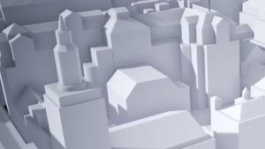
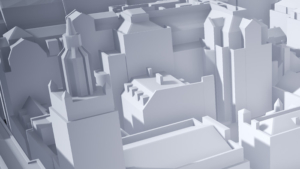
3D site models for planning by AccuCities®
Independent supplier to over 100 UK Architects & Planners
Proudly servicing the Planning and AEC industry for over 3 years, AccuCities have worked on over 1,400 small and medium-size 3D context models for sites all over the United Kingdom. Manually captured High Detail 3D models are accurate to 15cm in all axes (Our technology, Compare 3D models). AccuCities 3D site models are supplied in CAD solid, SketchUp or FBX formats.
Read our Reviews on Google, Examples of use in Planning or read our 3D cities Case Studies.

AccuCities Customer Reviews
5★ Rating on Google & Facebook
★★★★★
Amazing 3d context models for planning applications. Well worth it!!!!
Read on Google >
★★★★★
We recently purchased a large 3D model for a project in an area of North London which has seen a lot of recent development. We made enquiries at what had been our usual 3D mapping provider but their model was missing several recent developments. The people at AccuCities went out of their way to provide a more up to date model which even included buildings modelled from planning information. Very pleased with the service which was fast and very competitively priced. We will certainly be speaking to them again for the next project. Thanks AccuCities!
Read on Google >
★★★★★
We recently collaborated with the good people of AccuCities to assist us in delivering a compelling video content 3D animation. This became a fast forward fly-through experience looking at the future skyline of London in the year 2030. My client was looking to build video content for their new website homepage launch and AccuCities provides us with the assets of this accurate virtual experience of the London skyline. We highly recommend AccuCities and would collaborate with them again.
Read on Google >
Adam Rich
★★★★☆
Prompt service, multiple detail levels/file formats available, student/non-commercial discounts. Recommended!
Read on Google >
★★★★★
We work a lot with planning applications, where it’s important to have a reliable, trustworthy and professional technology partner. Our recent custom order of an Accucities model was turned around head of schedule, which is a rare commodity in this business! Very happy with the level of detail, and especially the cleanliness of the model. There are no gaps, inverted/double polygons/geometry or other shenanigans that I’ve seen elsewhere, just clean, welded and really well layered geometry. As part of a thoroughly professional service, the model is OS referenced, (X,Y,Z) so we could start using it both in in our CAD and visualization software with ease and confidence. I’m very impressed by all aspects of the service and the modelling, and I’m happy to recommend Accucities to any professional we’re working with.
Read on Google >
Simon Herrington
★★★★★
Great service and delivered on time.
Read on Google >
Ross Gribben
★★★★★
Read on Google >
Buy Custom 3D Models for Planning
Use our Quoting Tool for Instant Cost & Delivery Times estimates
Using our Quoting Tool is usually the quickest way to send us your requirements for a quote; the system now also displays Project Cost & Delivery time estimates* for your context 3D model. Simply find your site on a map and choose from one of the set-area boxes or draw an exact site boundary shape. If your site is already covered by our existing 3D city models library, the Quoting Tool will also display a clickable box grid of all available 500 x 500 meters tiles**. Enter your details and send us your quote request. We aim to come back to you within a few hours with a binding quote and payment options.
If you prefer, you can email us your site mark-up, map mark-up, 2D map or any other info about your site. Feel free to call our Call our Customer Support or Contact Us individually.