Welcome to AccuCities!
Our Custom 3D Site Models service now covers 98.5% of the UK
We are a specialist supplier of 3D models for planning to the industry. Using aerial imagery, not requiring a site visit, we manually capture 3D models of cities and as-built environments anywhere in the United Kingdom. 6 days average delivery time. Use our Quoting Tool to send us a map mark-up of the site you require.
RTPI Members and The Planner Readers can now get £300 OFF their first 3D site model. Send us your details below to receive your credit. You can use it on any AccuCities 3D model until May 2026.
What to Expect?
Previous Projects Costs & Delivery Times
Examples of previously delivered custom 3D Models used primary for Planning. See project cost & delivery times below. Your £300 Free Credit can be used for your first project with us, giving you up to 50% discount.
0.1 km2 model | Level 3
Custom Level 3 model of a site in Dingwall Road, Croydon
Delivered in 5 days for £500+VAT.

0.25 km2 model | Level 2
Custom Level 2 model of a site located in Bristol Waterfront
Delivered in 4 days for £750+VAT.

0.15 km2 model | Level 3
Custom Level 3 model of the Liverpool Cathedral.
Delivered in 6 days for £750+VAT.

0.33 km2 model | Level 2
Custom Level 2 model of a Birmingham Snow Hill site.
Delivered in 7 days for £866+VAT.

Why AccuCities?
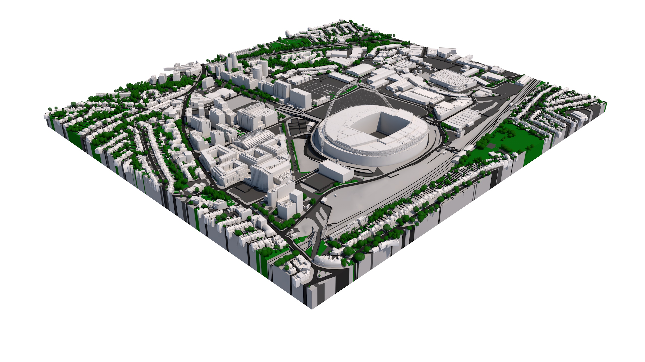
Over the last 8 years, AccuCities have worked with over 220 customers on over 4,900 small and medium-size 3D context models for sites all over the United Kingdom. We have also captured over 70 square kilometers of widely used High detail 3D London model and created a library of 3D city models. See how we are different.
3D data in layers

3D models are separated into layers such as Buildings, Roads, Greenspaces, Bridges, Embankment Walls and Trees layer.
Choice of File formats

Delivered in AutoCad Solid DWG, SketchUp SKP and Filmbox FBX formats. The 3D Model is easy to import into Revit, 3D Studio Max, Maya or Cinema 4D.
3D printing ready

The 3D Model of London is made with high-end 3D printing in mind. Files are easy to print using most office and professional 3D Printers.
Long 5 year Licence

Our licence allows unlimited number of users within the company to use of the 3D Model data on multiple projects.
Welcome to AccuCities!
Our Custom 3D Site Models service now covers 98.5% of the UK
We are a specialist supplier of 3D models for planning to the industry. Using aerial imagery, not requiring a site visit, we manually capture 3D models of cities and as-built environments anywhere in the United Kingdom.
RTPI Members and The Planner Readers can now get £300 OFF their first 3D site model. Send us your details below to receive your credit. You can use it on any AccuCities 3D model until May 2026.

Trusted by over 220 customers
Industry standard 3D Models for Planning
Over the last 8 years, AccuCities have worked with over 220 customers on over 4,900 small and medium-size 3D context models for sites all over the United Kingdom. We have also captured over 70 square kilometers of widely used High detail 3D London model and created a library of 3D city models. Our customers appreciate our personal approach and we appreciate our customers. Our complaint rate below 0.3% or our 5 star Google rating. Request a quote today and see how we are different.
3D data in layers
Easy to work with
3D models are separated into layers such as Buildings, Roads, Greenspaces, Bridges, Embankment Walls and Trees layer.
Choice of File formats
Best 3D Models for Planning
Delivered in AutoCad Solid DWG, SketchUp SKP and Filmbox FBX formats. The 3D Model is easy to import into Revit, 3D Studio Max, Maya or Cinema 4D.
3D printing ready
Flawless results at small scales
The 3D Model of London is made with high-end 3D printing in mind. Files are easy to print using most office and professional 3D Printers.
Long 5 year Licence
Unlimited Users & Projects
Our licence allows unlimited number of users within the company to use of the 3D Model data on multiple projects.
3D City Modelling Technology
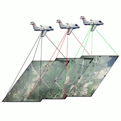
Aerial mapping using Stereo Photogrammetry
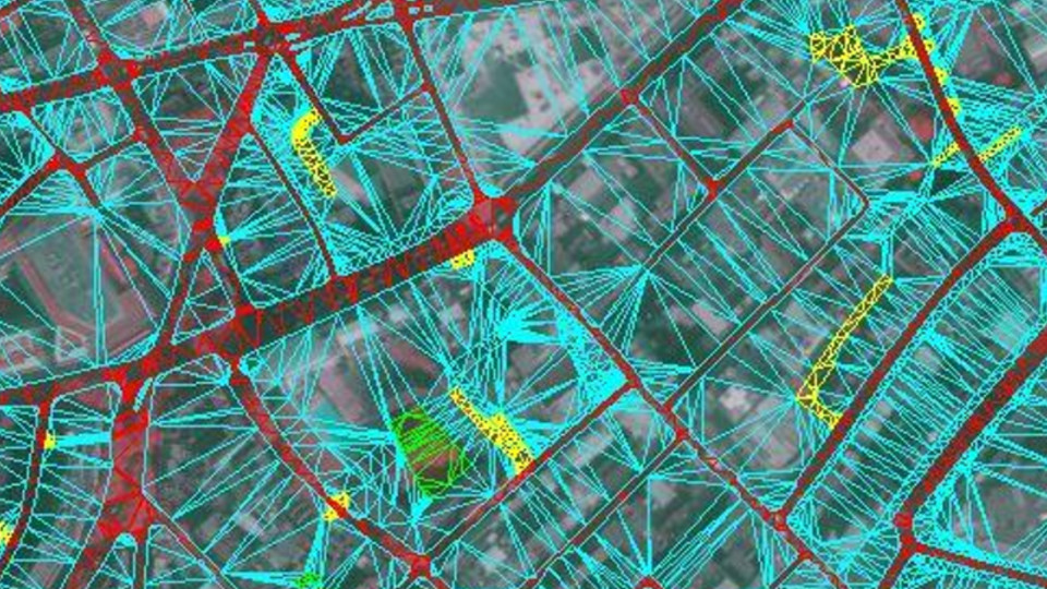
Photogrammetry is the science of making measurements from photographs. It is a photography with a purpose – to accurately measure from it.
We use stereo photogrammetry using latest high-resolution aerial imagery to capture our 3D Models. The aerial imagery collection is done using fixed-wing aircraft. As the aerial mapping plane flies over a city area, it takes series of photographs which overlap by 60%. With each photograph its GPS position, height, tilt, pitch and roll are recorded. Using this data + camera calibration data (to eliminate lens distortion effects), the imagery is triangulated to its correct real-world coordinates.
In areas where two images overlap, we project one image into one eye, the second image into another eye and and this way we are able to see the Z value (depth). We then manually capture this point.
Latest Aerial Imagery
Working with all major suppliers
We are working with every major aerial imagery supplier to ensure your 3D site map will be captured from as recent imagery as possible.
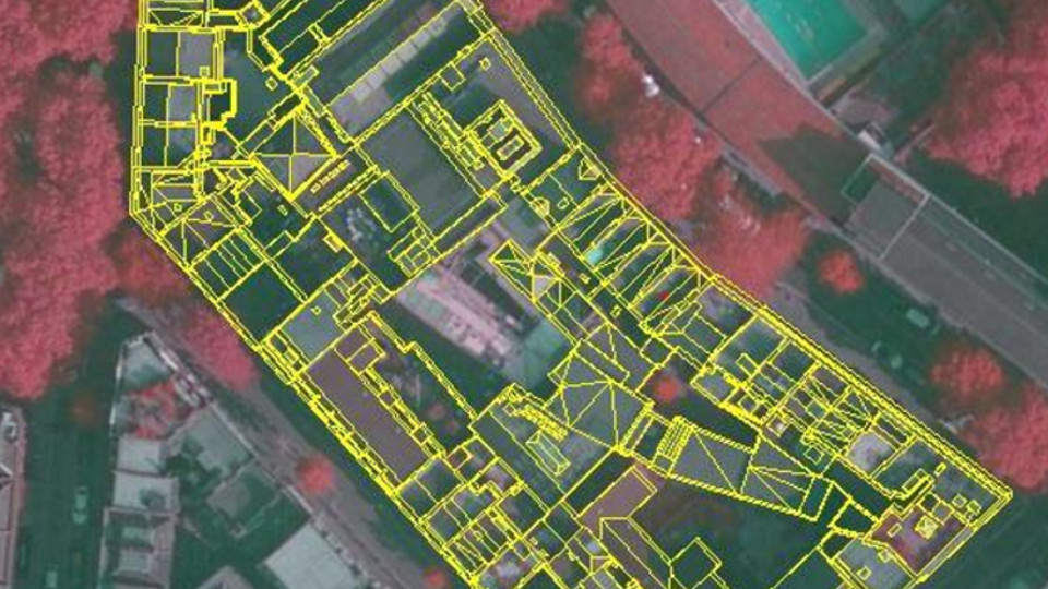
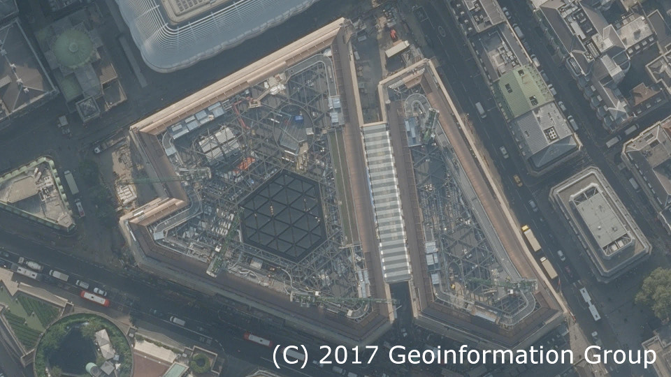
Mapping 3D buildings
Every line manually mapped
All features are captured manually to the specification of either Level 2 or Level 3 models. Using aerial mapping technique, we determine the height of the feature for capture.
Terrain Heights Mapped
3D separated Terrain
The terrain is manually captured and is accurate to 20cm in all axis at curb level. It is separated into land use categories such as roads, man-made surfaces, greenspaces or water body.

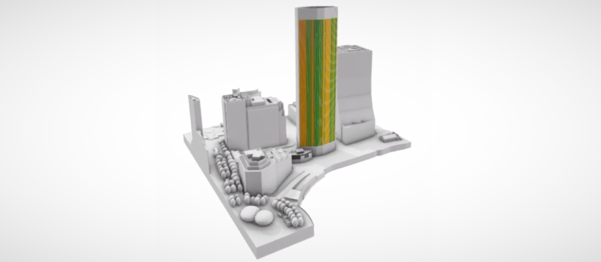
Future Skyline
Included where available
We constantly update our models with 3D models of consented developments. Available for Battersea, Nine Elms, Southbank, Blackfriers, City of London and Canary Wharf.
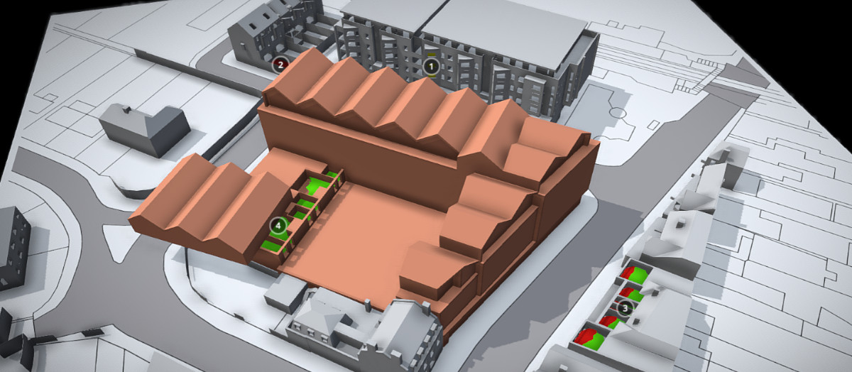
Custom 3D Models Examples & Samples
Supplying Architects and Planners Since 2017
Examples of previously delivered custom 3D Models used primary for Planning. See project cost & delivery times below. You can view these examples using online viewer or even download them in CAD, SketchUp or FBX formats. Samples are available in both local and UK national grid coordinates.
Examples of Use: 3D Models in Planning
From House Extensions to Urban Masterplans
Examples of how our customers use AccuCities 3D Models for Planning. Daylight, Sunlight & Overshadowing Studies, Pedestrian Wind Comfort Study, Initial Masterplan Public Consultation Boards and even in public engagements using 3D Models instead of 2D maps.
Customer Case Studies
Examples of how our customers use AccuCities 3D Models for Planning. Daylight, Sunlight & Overshadowing Studies, Pedestrian Wind Comfort Study, Initial Masterplan Public Consultation Boards and even in public engagements using 3D Models instead of 2D maps.


AccuCities Customer Reviews
5★ Rating on Google & Facebook
★★★★★
Amazing 3d context models for planning applications. Well worth it!!!!
Read on Google >
★★★★★
We recently purchased a large 3D model for a project in an area of North London which has seen a lot of recent development. We made enquiries at what had been our usual 3D mapping provider but their model was missing several recent developments. The people at AccuCities went out of their way to provide a more up to date model which even included buildings modelled from planning information. Very pleased with the service which was fast and very competitively priced. We will certainly be speaking to them again for the next project. Thanks AccuCities!
Read on Google >
★★★★★
We recently collaborated with the good people of AccuCities to assist us in delivering a compelling video content 3D animation. This became a fast forward fly-through experience looking at the future skyline of London in the year 2030. My client was looking to build video content for their new website homepage launch and AccuCities provides us with the assets of this accurate virtual experience of the London skyline. We highly recommend AccuCities and would collaborate with them again.
Read on Google >
Adam Rich
★★★★☆
Prompt service, multiple detail levels/file formats available, student/non-commercial discounts. Recommended!
Read on Google >
★★★★★
We work a lot with planning applications, where it’s important to have a reliable, trustworthy and professional technology partner. Our recent custom order of an Accucities model was turned around head of schedule, which is a rare commodity in this business! Very happy with the level of detail, and especially the cleanliness of the model. There are no gaps, inverted/double polygons/geometry or other shenanigans that I’ve seen elsewhere, just clean, welded and really well layered geometry. As part of a thoroughly professional service, the model is OS referenced, (X,Y,Z) so we could start using it both in in our CAD and visualization software with ease and confidence. I’m very impressed by all aspects of the service and the modelling, and I’m happy to recommend Accucities to any professional we’re working with.
Read on Google >
Simon Herrington
★★★★★
Great service and delivered on time.
Read on Google >
Ross Gribben
★★★★★
Read on Google >
Top Planning Consultants use AccuCities 3D City Models
